Red River urban zoning planning: Untie the ‘stumbling’ projects for decades
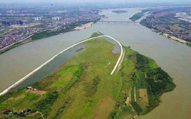
Currently, tens of thousands of hectares of land along the banks of the Red River are left fallow, encroached on or exploited inefficiently. The Red River urban zoning plan was approved as a “golden key” opening the door between the inner city and the two banks of the Red River.

In 1992, households in Yen Phu ward (Tay Ho district) received a notice from the ward government about the agreement to compensate the land for the city to implement the Song Hong City project. Since then, it has been nearly 30 years, the project has not been implemented, people have to live temporarily in their own houses.
The Song Hong City project has been approved for a detailed planning of 1/500 scale since 1995, within the research boundary of the Red River urban subdivision planning that has not been approved by the competent authority.
The process of studying and adjusting the planning This project needs to be in sync with the study of the Red River urban subdivision planning. Meanwhile, the Red River urban subdivision planning is still “hanging” because it is not consistent with the Prime Minister’s Decision No. 257/QD-TTg dated February 18, 2016 on the approval of the Prevention and Control Plan. flood and dyke planning for the Red and Thai Binh river systems.
Across the Red River is an area of hundreds of hectares outside the dyke in Long Bien district, which is left fallow. In which 3 big projects are housing, villas of Him Lam Joint Stock Company, Golf course project, Giang Bien Port project. A representative of Long Bien District People’s Committee said that when there was an investment mechanism in the form of BT (build-transfer) in exchange for land for infrastructure, some businesses carried out works in exchange for riverside land. However, due to the lack of zoning planning, the centralized planning cannot be established, and the land cannot be exploited. “If the Red River subdivision planning is implemented, there will certainly be prosperity of riverside real estate projects,” said a representative of Long Bien District People’s Committee.
Along the Red River route from Dan Phuong district to Tay Ho district (Hanoi) – the area of agricultural land, alluvial land along the river is thousands of hectares wide. Currently, households here are only temporarily exploited because there is no planning, only 5 years at most.
Dan Phuong district leader said that the district has 3 communes Lien Trung, Lien Hong and Lien Ha that cultivate agriculture in the alluvial soil outside the dyke. The land outside the dyke can only be rented for a maximum of 5 years, so some enthusiastic investors who want to invest in high-tech agriculture, net houses… have not dared to deploy.
Relieve frustration for thousands of households
The planning of the Red River urban zoning has not been approved, which means that many projects do not have a basis to adjust the planning and construction. Besides, the order of construction and urban management in this area becomes a burden for local authorities.
Survey in wards Nhat Tan, Tu Lien, Yen Phu (Tay Ho district), Chuong Duong, Phuc Tan (Hoan Kiem district), Bach Dang, Thanh Luong (Hai Ba Trung district)… same hard work. Due to the unapproved planning, many people struggle to live on their own land. Anh Linh (Yen Phu ward) said that in order to get a construction permit, he had to work hard to get a dyke agreement with the Hanoi Department of Agriculture and Rural Development. Permits are also granted only temporarily for limited height construction.
In Nhat Tan ward (Tay Ho district), there are about hundreds of households living and building houses along the Red River dike. Although many households have lived stably for many years, there are still cases of encroachment on agricultural land (traffic) to build houses. This makes it difficult for the ward government to check and enforce the violating works.
Mr. Tran Xuan Ha, Secretary and Chairman of the People’s Committee of Phuc Tan Ward (Hoan Kiem District), said that as a ward in the central district, construction problems faced many difficulties. In addition to the areas licensed for temporary construction, new construction along the riverbank is not allowed. Households living here are only allowed to renovate their houses when they are degraded.
Director of the Hanoi Institute of Construction Planning Luu Quang Huy said that the sooner the plan is approved, the more convenient it is to manage the construction order and call for investors to go to areas outside the dike. The plan will solve the frustrations of people outside the dike for many years.
Talking to the press about the Red River urban zoning planning that has just been submitted by the City People’s Committee to the Hanoi Party Committee, Vice Chairman of the City People’s Committee Duong Duc Tuan informed: “Hanoi will aim to build this area into an ecological urban, connecting the north and south of the Red River. These will be specific values, separate spaces and are the main content of the general planning to build the future Hanoi capital.”
Vice Chairman of Hanoi People’s Committee Duong Duc Tuan said that the Red River urban subdivision is located on a 40 km long river section, with a land fund of about 11,000 hectares. The planning belongs to the administrative boundaries of 55 wards and communes in the area of 13 districts. The estimated population according to the plan ranges from 280,000 to 320,000 people. “In the past, we used to say that the city turned its back on the Red River, coming here will face the Red River to create an important spatial axis and green corridor,” said Mr. Tuan.
According to Tran Hoang
Vanguard


